Deer Recovery - Aerovision Drone LLC
Rapid Aerial Search and Recovery for Lost Livestock and Pets
Aerovision Drone LLC provides specialized deer recovery and livestock/pet recovery services designed to locate and reunite animals with owners quickly. Operating from Linn, MO, our drone-based recovery teams deploy thermal and high-resolution visual sensors to scan large areas efficiently, reducing the search time and improving recovery outcomes. Whether a deer is trapped, a livestock animal has wandered, or a pet is lost in rough terrain, Aerovision Drone LLC offers fast, humane, and effective aerial assistance.

Why Deer and Livestock Recovery Matters
Missed or lost animals represent a significant emotional and economic burden for owners. Traditional search methods can take hours or days and often cover limited ground. Drone-based recovery solves key challenges:
Rapid Coverage: Drones can survey large swaths quickly, including rugged, inaccessible, or densely wooded terrain.
Enhanced Detection: Thermal sensors detect body heat signatures at long range, especially valuable at dawn, dusk, or night.
Reduced Animal Stress: Quick detection reduces time animals spend lost, decreasing injury, predation risk, and stress.
Cost and Time Savings: Faster searches reduce manpower hours and can prevent prolonged livestock loss.
Key Benefits of Aerial Recovery Services
Speed
Locate missing animals faster than ground searches.
Accuracy
Thermal and visual sensors improve detection rates, even in dense cover.
Safety
Protect search crews from hazards such as rough terrain or water crossings by conducting initial aerial searches.
Documentation
GPS coordinates and imagery assist in ground navigation to the animal’s location and provide evidence for insurance or veterinary needs.
Humane Handling
Rapid location increases odds of recovering animals unharmed and reduces the need for more invasive recovery methods.
How Aerovision Drone LLC Conducts Deer Recovery
Initial Call and Assessment
Rapid Intake: When you contact us, we collect location, last-seen information, animal description, and any recent movement patterns.
Response Planning: Based on the site and urgency, we determine the best sensor package (thermal vs. visual), flight path, and time of day for optimal detection.
Aerial Search and Detection
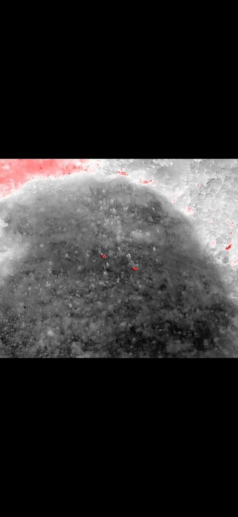
Thermal Imaging: Thermal cameras identify heat signatures, particularly effective for locating warm-blooded animals in cool conditions or through light cover.
Visual Scouting: High-resolution cameras capture imagery for identification and situational awareness in daylight conditions.
Systematic Coverage: We divide search areas into grids and systematically scan to ensure thoroughness and reduce the chance of missed animals.
Coordination with Ground Teams
GPS Coordinates: We provide precise coordinates and images to ground teams for humane retrieval.
Safety Briefing: If a ground recovery is needed, we guide teams on approach and provide any on-site observations relevant to safety.
Live Guidance: In urgent scenarios, we can provide live-streamed video to aid ground teams during approach and capture.
Case Scenarios and Typical Outcomes
Trapped Deer: Thermal imaging located a deer down in a steep ravine, enabling a safe retrieval by a coordinated ground team with minimal delay.
Wandering Cattle: A missing cow was located quickly in a wooded creek bottom, allowing for a calm recovery before the animal wandered farther.
Lost Pets: Dogs or other pets found within hours of being reported missing were reunited with owners, reducing trauma and replacement costs.
Advantages over Traditional Methods
Advantages over Traditional Methods
Better detection in dense vegetation or over wide areas.
Reduced risk for search teams by limiting ground exposure until accurate locations are identified.
Operational Considerations and Ethics
Respect for Wildlife: For non-domestic wildlife, we prioritize non-disturbance policies. Our role is to locate animals; we coordinate with wildlife agencies if relocation or handling is necessary.
Owner Authorization: We operate on private property only with owner consent and coordinate with landowners and local authorities as needed.
Night Operations: Thermal-enabled night flights increase detection probability during cooler periods, though local regulations and safety are strictly observed.
Pricing and Response Time
Response depends on weather, distance, and time of day. We strive to prioritize urgent requests and will provide an estimated arrival time during the initial call.
Pricing is project-based and reflects search time, sensor use, and coordination complexity. Call (573) 578-5005 for a prompt estimate when you need immediate assistance.
Frequently Asked Questions — Deer Recovery
How accurate are thermal sensors for locating animals?
Thermal sensors are highly effective at detecting warm-body heat signatures, especially when ambient temperatures are cooler. Dense canopy or extreme thermal backgrounds can affect detection, but systematic scanning improves success.
Can you operate at night?
Yes. Night operations using thermal cameras are a key capability, though they are conducted only under safe, legal conditions.
Do you handle wildlife or only domestic livestock and pets?
We respond to both situations. For wild animals, we focus on location and contact wildlife authorities for humane handling if needed.
What should I do while awaiting drone assistance?
Provide clear directions to the search area, any recent animal movement details, and ensure access for ground teams if recovery is possible once located.
book now
Contact Us
We will get back to you as soon as possible.
Please try again later.
Contact Us
For urgent recovery assistance, call (573) 578-5005. Provide your location, a description of the animal, and the last known sighting. Our team will triage requests and prioritize immediate deployments where possible.